If you’ve been following the national weather this week, you might be wondering if the groundhog has developed a split personality this year. Is winter over or are we in for six more weeks of cold? While the eastern half of the United States is feeling the effects of record-setting high temperatures and one of the earliest springs on record, the western U. S. is observing cold and snowy conditions all the way down into Southern California. I’ve heard reports of snow reaching all the way down to Tucson in southern Arizona.

What is an atmospheric wave?
Some of you may be wondering how we can have some tremendous differences between the eastern and western U. S. at the same time. The reason we see such differences is linked to the wavy pattern of the upper atmosphere, which helps direct warm or cold air into different regions. Today I will discuss atmospheric waves and how they affect the surface weather.
Since air is a fluid, it should not be surprising that it has waves in it. In fact, there are many different types of waves that can occur in the atmosphere, ranging from small-scale pressure waves downwind of mountain ranges to the largest planetary-scale oscillations in pressure. Sometimes you can see some of those smaller-scale waves in clouds occurring above you.

Where do atmospheric waves come from?
What ultimately drives the atmospheric circulation is the temperature difference between the equator which is warm due to direct sunlight and the poles which are cold because whatever little sun they get, especially in winter, is of low angle and there is not much solar energy reaching the surface to heat things up. This temperature difference causes a difference in atmospheric pressure that makes winds blow to try and equalize those differences.
Variations in land versus sea, the rotation of the planet, and differential heating from other causes like drought all contribute to the atmospheric developing waves that look like large swings in the pressure patterns at mid-levels in the atmosphere. Areas where the pressure is low are called troughs and areas where it is high are called ridges, like the patterns we see in topographic maps. Surface fronts are located near the boundary between troughs and ridges where the contrast in temperature and humidity is often the greatest.
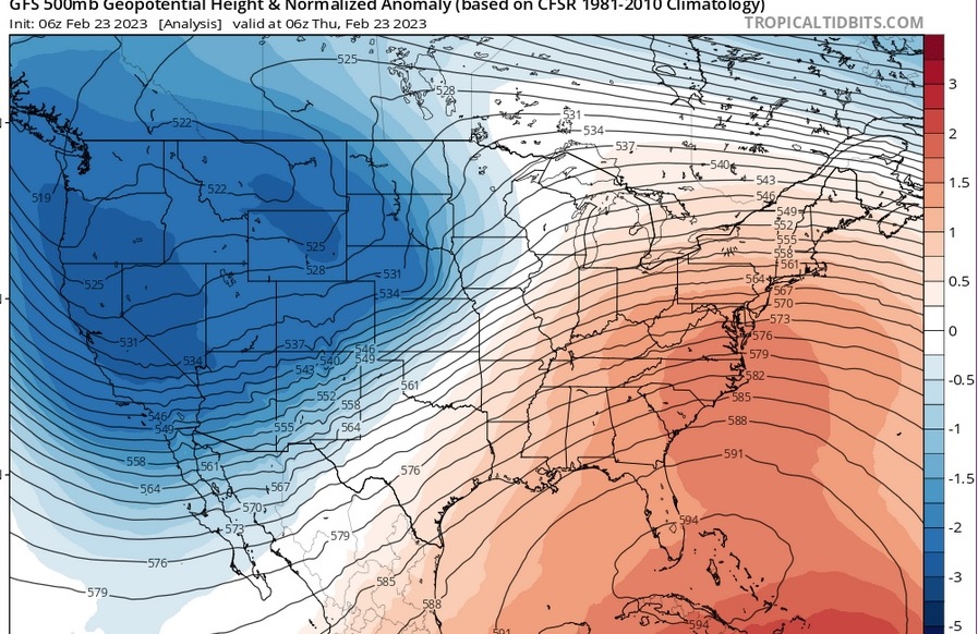
How is the current wave pattern driving these big temperature swings?
This week there is a tremendous ridge of high pressure located in the eastern US while a very deep trough is located over the western part of the country. Warm air blowing up from the south under the ridge has brought record-setting high temperatures to many parts of the East, while cold air blowing in from the north behind a strong surface low pressure center has caused winter storm and blizzard warnings all the way south to the mountains near San Diego. Record-setting low temperature and wintry conditions are occurring in those areas.
The warm temperatures in the East are of special concern for gardeners since they have caused the first leaves and blossoms to occur as much as a month early in some locations, according to the National Phenology Network. Since the average frost date for those areas is a month or two later, the likelihood of damage to fruit crops is high since freezing temperatures could significantly reduce the production of fruit in gardens and orchards if they occur in the next month or two. It could also cause damage to many other flowering plants that are fooled into blooming early due to the unusual warmth.

Will atmospheric wave patterns change in a warmer world?
Is the unusual warmth due to global warming? This is a hotly debated topic (if you will excuse the pun) with both proponents and skeptics weighing in. Many scientists believe that as the arctic regions warm up faster than the equator (a process known as “Arctic amplification”), the atmospheric wave patterns will become more amplified, with both deeper troughs and stronger ridges occurring. That could mean more extremes in both hot and cold weather as these waves occur. Other scientists caution, however, that the computer models used to study the large-scale wave patterns don’t always agree with global warming as a root cause. If we do have generally warmer conditions that are punctuated by significant cold outflows our gardens will have to be able to survive the increasing variability of the weather, especially in winter and spring when there is still a significant pool of cold, dry air near the poles available to flow south into mid-latitudes.

Please feel free to share how this crazy weather has impacted your own garden. Are your trees blooming early, or has snow covered everything? If you are not in the United States, what do you see going on in your own neighborhood? We are interested to know!
I’m located in the southern part of the North Carolina coast and in the past several days we set heat records. This winter has been more up and down than usual, but we did have a decent amount of cold temps earlier, so plants that require chill hours will be happy come spring.
I’m in the mountains of SoCal,and we have soooo much snow, we’ve run out of room to put it anywhere ! We have a lot of mature fruit trees, and the snow level has reached the highest branches in some cases ! I hope they’ll all survive because it’s been really cold since mid November!
Houston: 2 years ago snow and freeze to 6° on Valentine’s day, with last freeze of the season 3/14. This year, it’s been warm early and my fruit trees have already bloomed and are setting fruit.
Here in central VA, everything is coming out several weeks early, in some cases well over a month early. I dread a 2007 type of year where we had several weeks of warm to almost hot weather leading up to an April Easter snow and low 20s.
What are your thoughts on arctic warming leading to more late winter polar vortex disruptions? It seems here we are in a long-term trend of mild/warm autumns with sometimes little frost before deep freezes and springs featuring frequent cold shots. I know predictions of the polar vortex get a lot of (deserved, maybe?) criticism, but the idea of late winter/early spring disruptions seem to have some truth to it.
I have noticed some more frequent warm winters followed by late cold outbreaks, but don’t know if this is a long-term trend yet or just more noticeable due to my paying more attention to it. The Southeast seems to be more prone to it than other areas, so some of it may be my perception from living in Georgia. If it is a real trend, it will be a big problem for fruit-growers since the trees and bushes will bloom early and then have big losses due to late frost.
St. Louis: I guess we are right in the middle and avoiding everyone else’s extremes, or as we always say here, ahh yesss, this weather (whatever it may be) just wait a day or so and it will be the opposite.