NOAA recently announced that La Niña is favored to continue through summer and fall this year and could last through next spring. This forecast is bound to strike fear in gardeners in the western United States, since La Niña is associated with drought in the western parts of the country which sorely needs more rain. Los Angeles has announced some stringent watering restrictions due to impending water shortages, and that means gardeners will have to be especially careful there to use the water they have wisely.

What is La Niña?
Many people have heard the terms La Niña and El Niño but for those who don’t, let me take a few minutes to describe them. You can also read more in my blog post from last fall when this winter’s La Niña was just getting going. El Niño and La Niña are two opposite phases of an oscillation in the atmosphere and ocean in the Eastern Pacific, with neutral conditions in between the two phases as the oscillation swings back and forth like a seesaw. When that region’s sea surface temperature is warmer than usual near the equator, rising air above the warm water creates thunderstorms which act like a rock in a river diverting the flow of air along the southern US, especially in winter when El Niño and La Niña are usually strongest.
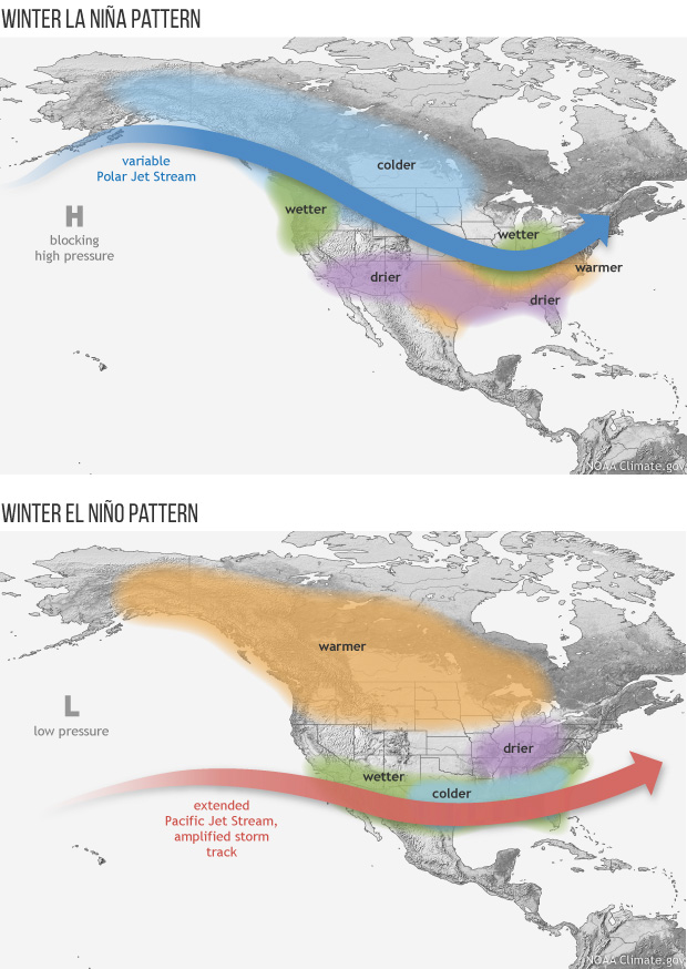
In El Niño winters, the Southeast is usually wetter and cooler than usual due to the presence of the subtropical jet stream overhead. It pushes storms with their associated rain and cloudy conditions through the region, recharging soil moisture for the next growing season. In La Niña winters, the jet stream is shifted to the north over the Ohio River Valley, leaving the Southeast warm, dry, and sunny. That means conditions for severe weather are more favorable in the Southeast than in other phases; we have certainly seen plenty of that this year so far. The lack of a strong jet stream also means that tropical activity in the Atlantic Ocean is more frequent and stronger than in El Niño years. In northern parts of the country La Niña winters are usually cold and snowy with a late start to spring, as we have seen this year. The Pacific Northwest is often wet, which also matches what has occurred in their coastal areas this year.

How often does a third year of La Niña occur?
The atmosphere usually swings back and forth between El Niño and La Niña roughly every 3-5 years. Right now we are ending a second consecutive winter of La Niña; with its predicted continuation, that would make it three years in a row. This is not unprecedented, but it is certainly unusual, since 1950 we have only had two “triple-dip” La Niñas. Since there are so few direct comparisons it can be hard to determine exactly what to expect this growing season and on into fall and winter. Our best bet is to assume that typical La Niña conditions will occur. The 3-month composites of the expected anomalies (differences from average; MAM means March-April-May, etc.) show the seasonal variability of El Niño and La Niña for temperature and precipitation across the US. La Niña and El Niño’s effects stretch far beyond the US and affect global weather patterns.

What does this mean for the growing season across the United States?
Typically effects from a La Niña are weakest in the summer because sea surface temperature anomalies are not strong and is often switching from La Niña through neutral conditions to an El Niño the next year. However this year the La Niña is still going strong, so this seems less likely. That means the pattern of warm and dry southern states are likely to continue, which is trouble for the already drought-ridden Southwest including California (where severe water restrictions are now in place). With the high temperatures, low rainfall, and low humidity, that means water stress on gardens will be higher than normal, and drought and wildfires could dominate that part of the country for the next few months.
In the Southeast, the active spring severe weather season will likely give way to an active tropical season in summer and fall. Rainfall in the Southeast in summer is dominated by tropical systems and small-scale convective rain events that provide only hit-or-miss rain. If you are in the path of a tropical storm, you can experience several inches of rain while areas a few counties away can see none, resulting in a feast or famine of rain. In the Pacific Northwest wet conditions in coastal areas will give way to drier conditions in the summer but may return again in the fall, while inland areas may continue to see very dry conditions that will lead to increasing drought and water shortages. The Northeast could see wetter than normal conditions so a drought there this year seems unlikely. The central part of the United States could be the hardest hit by drought conditions and the drought that is already present across a large part of the central and western US is likely to get worse over the next few months with little rain expected. That will affect not only gardeners but the farmers of the main grain-growing area of the US, at a time when Ukraine, normally a big grain producer, is not likely to be able to produce a regular crop this year because of the ongoing war.

Managing your garden in La Niña
Gardeners in the Southwestern US will have the most difficult conditions to manage this year due to the water restrictions and ongoing drought there. Proper use of irrigation and conserving soil moisture through mulch and appropriate choice of plants are good ways to keep water use lower. This may also be true of gardeners in the central US, where the drought could also be severe this summer. In the Southeast, the summer rain you get will depend on tropical activity and where the storms go so you could see either wet or dry conditions. Managing your garden for both dry periods and potentially heavy rains is a challenge that you may need to deal with this year. In the Northeast, the climate may be easier to contend with this year but even short-term dryness can be a problem for plants that need regular infusions of water. In the Pacific Northwest, predictions for a warmer and drier than usual summer mean you should pay careful attention to water-conserving measures, especially in inland areas where drought is already a problem. If you are outside the US, then make sure you understand how La Niña is likely to affect your region and manage your garden accordingly.
Thanks. very helpful
In the last paragraph, I wish there was a comment on the Northwest as well as the 4 other regions.
I added a sentence for you to address this.
Thank you. I enjoyed reading the article and understand El Niño and La Niña better now.