You’ve probably seen Neem oil recommended in blogs, gardening forums, and on the shelf at your local gardening store. Neem is derived from the seeds of the Azadirachta indica tree, and is one type of horticultural oil that is used by gardeners looking for alternatives to synthetic insecticides. But is it effective? Is it benign? This post explores the pros and cons behind neem and other horticultural oils.
What Are Horticultural Oils?
Horticultural oils are either plant-based (like neem, canola, or clove oil) or mineral-based (refined petroleum products), and they work mostly by smothering soft-bodied pests like aphids, scale, and whiteflies.
Some plant-based oils do contain chemical compounds that can do more than smoother —neem oil contains azadirachtin, which disrupts insect development and feeding behavior.
Horticultural oils are typically considered low-toxicity for humans, and can be used on a very wide range of plants, including vegetables, fruits, ornamentals, and houseplants.
The PROS
Broad-Spectrum Neem oil is effective against a range of insect pests and some fungal diseases, yet remains relatively safe for humans, pets, and other animals. According to the Environmental Protection Agency neem oil “has been shown to have minimal impact on non-target organisms” (EPA, 2012) such as birds and mammals.
Reduced Resistance Potential Unlike synthetic insecticides that often target a specific physiological pathway (and thus promote resistance over time), neem oil affects multiple aspects of insect development, which makes resistance less likely to develop quickly.
Organic-compatible and easy-to-apply Neem and other horticultural oils are generally approved for organic gardening. interventions. They are easy for home gardeners to use since you can spray from a store-bought bottle and avoid any special equipment.
Low Residual Activity These oils break down quickly in sunlight and soil, reducing long-term environmental contamination and residue on edible crops.
The Cons
Phytotoxicity Risk If you use oils in high temperature or direct sunlight, it can lead to leaf burn and plant damage. Apply it early in the morning or late in the day to minimize this risk.
Non-Selective Action Neem and other oils can still harm beneficial insects if sprayed directly. Lady beetles, lacewings, and bees can be affected by fresh residues. You can time your application to avoid flowering periods, or spray during the evening when bees are less active to avoid non-target impacts.
Repeat applications sometimes required The effects of oils can take days to manifest and may require repeated applications (e.g. every 10 days) for best results. Gardeners expecting immediate eradication may be disappointed. Oils often work best in conjuction with other control strategies (e.g. pruning out infested areas, releasing beneficials, etc.)
Storage and Shelf Life Oils can degrade over time, especially when exposed to light and heat. They can go rancid or lose efficaciousness. Check the expiration date on your bottle and store in a cool, dark place.
Concluding Thoughts
I like horticultural oils. They can be effective tools and are safe for people to use. But they need to be used with some consideration, particularly timing to avoid non-target impacts to beneficial insects and leaf burn. Let me know your experience with oils.
Have you ever stopped while you were gardening to look at the clouds? Clouds, like flowers, come in a variety of shapes and sizes that can form beautiful patterns in the sky. But clouds are not just pretty, they can also be used to make predictions about the weather in the coming days. In this week’s post, we will look at the different types of clouds and how they relate to coming weather. You can use that to prepare for your garden work by knowing when it will be sunny and predicting when rain is coming.
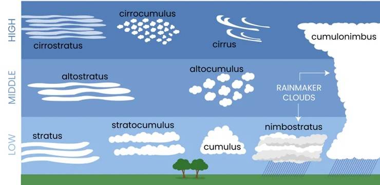
Clouds were first classified by Luke Howard in 1803 in his “Essay of the Modifications of Clouds”. Howard classified the clouds by their shape, using Latin names for wisps (cirrus), lumps (cumulus), or sheets (stratus) to describe how they looked in the sky. Clouds that are precipitating either rain or snow are called nimbus clouds. Some clouds are a combination of types, such as stratocumulus clouds, which look like a layer of lumpy clouds, or cumulonimbus clouds, which are the tall thunderstorms that form in summer. You can find a great gallery of cloud photos at the Cloud Appreciation Society. Wikipedia has an exhaustive list of cloud types online as well.
Clouds are also classified by heights. Most clouds form in a single layer of the atmosphere, but you can often see multiple layers of clouds when you look at the sky. These layers may be caused by different mechanisms. The shape and height of the clouds provide clues to what is going on in the atmosphere and are especially related to the presence (and sometimes absence) of warm and cold fronts that are harbingers of precipitation and a change in wind and temperature conditions.
There are many different types of clouds, each with a unique shape and location in the sky. UCAR/L.S. Gardiner
To estimate how high the clouds are, you can use a literal “rule of thumb” that works well for cumulus-type clouds. Hold your hand out towards a cloud. If the individual cloud is the size of your fist, then it is probably a low cloud. If the lump of cloud is the size of your thumb, then it is probably a mid-level cloud. And if it is the size of your little pinky joint, then it is probably a high cloud. Note that the clouds are the same size, but the difference in height makes them look like they are different sizes.
For stratus clouds, you can estimate the height by how transparent it is. A cloud layer that allows you to clearly see where the sun or moon is located is probably a high cloud. A layer that lets you see where the sun is but shows it with blurry edges (we sometimes call this a “ground glass” appearance), then it is probably a mid-level cloud. If it is so thick that you cannot see where the sun or moon is, then it is probably a low-level cloud. But please be careful not to look directly at the sun, since it can damage your eyes!
How do clouds form?
Clouds form where moist air cools off to the point that the water vapor condenses into small drops that become visible to us. Since the atmosphere generally cools off as you go up, the clouds form where the air is rising. The rising motion can be provided by heating from the earth’s surface, lifting of the air by a mountain, or large-scale upward motion caused by warm and cold fronts, where masses of air at different temperatures interact to create areas of rising air. The highest clouds usually form in the coldest air and form as ice crystals, leading to their wispy appearance. Lower clouds appear in warmer air where the water condenses as liquid droplets, leading to their more robust appearance.
Clouds associated with cold and warm fronts, U. K. Met Office.
How are cloud shapes related to atmospheric winds and structure?
The most interesting weather (at least to me, as a meteorologist) is where there are differences between masses of air at the surface and above the surface that are interacting. Boundaries between these air masses are called “fronts” and are named because they act like battle fronts between enemy armies. In a cold front (left side of diagram above), cold dense air near the surface pushes beneath a layer of warm, humid air, causing it to rise and cool. Clouds ahead of cold fronts tend to be relatively tall and energetic and form cumulonimbus clouds that can drop a lot of rain in a short time but generally tend to move through an area quickly unless the front stalls due to other atmospheric dynamics.
Warm fronts are large masses of warm, humid air that are pushing over the top of a layer of colder, more dense air (right side of diagram above). As the warm air rises, it slowly forms clouds as the layer cools to the temperature of condensation. Since the entire layer is rising, the clouds that form are often sheets of clouds rather than individual clouds. The higher clouds indicate that the moisture from an approaching warm front is present high in the atmosphere and shows that a warm front is likely to be approaching, signaling a change in the weather from cool to warmer conditions that could also drop rain as the warm front gets closer to your location. As the warm front gets closer, you should see the high clouds replaced by mid-level clouds like altostratus and then lower clouds like stratus clouds and nimbus clouds if they start producing rain. This usually happens over a day or two depending on the speed and strength of the surface warm front.
If you see lumpy cloud forms, then they are most likely related to the rising motion of air due to columns of warm air rising from the surface (“thermals”). Air between the columns is sinking, which leaves clear spots between the clouds. Fair-weather cumulus clouds are the tops of these thermals, when the rising air cools down enough for the water vapor in the column to condense, forming the cloud. These types of clouds usually form when the ground is heated, most often by sunlight during the day but sometimes by pavement or wildfire as well as mountainous areas. They usually form on days when you are in a mass of warm, humid air that is far from a frontal boundary, although if they grow taller, then a cold front is likely to be approaching.
If the air is very hot and humid and the surrounding air is cooler than the rising column, then the clouds can grow vertically to great heights before they hit a layer that is warmer than the rising air and stop growing. These tall clouds are called cumulonimbus clouds because they often drop heavy rain as they develop. These often form along and ahead of cold fronts and indicate that the wind is likely to shift from a south wind to a colder wind coming from the northwest (in the Northern Hemisphere). In the worst cases, the rain can cause erosion or damage to fragile plants when it is very intense. Plants that live in rainy areas evolve to have such things as pointed tips or shiny leaf surfaces that shed the water quickly. Cumulonimbus clouds are also sometimes associated with high winds, hail, and tornadoes, all of which can damage garden plants and trees as well as harm humans and animals.
Cirrostratus clouds being illuminated by the sun and forming a halo, Eduardo Marquetti, Commons Wikimedia.
How can you predict the weather by watching the clouds?
As you work in your garden, take a look at the clouds above you. If they are high and wispy, then moisture high in the atmosphere may indicate that a warm front and a chance of rain is likely in a couple of days, especially if they get lower and denser over time. The picture of daisies at the beginning of this post shows high, wispy clouds that could indicate a warm front is approaching. The glowing ring of light that appears in cirrostratus clouds in the picture just above this paragraph may also be a sign that there is moisture on the way, leading to the saying that “a ring around the moon means rain in 48 hours”.
The chance of rain may affect your plans to spray your gardens or lawns for pests or fungal diseases, since many garden treatments have weather-related requirements for when to use them. Some work better when applied to wet leaves after rain falls, but others need a period of dry weather for the chemicals to be most effective. Make sure you read the labels to know what kind of weather they need. It may also tell you that it would be a good idea to mow the grass before it rains in the next 24-48 hours.
An Intercity from Amsterdam to Den Helder passes a field in full bloom near Schagen, Netherlands, Kabelleger / David Gubler, Commons Wikimedia.
If you are already in hot and humid conditions and you see cumulus clouds getting taller and more numerous over time, a cold front may be approaching. This could indicate a period of strong winds, heavy rain, some possible lightning, and sharply cooler temperatures which could be either a curse or a blessing depending on just how hot it has been. The very shallow clouds in the picture above (cumulus humilis) are most likely seen after the cold front has passed and there is minimal lifting to cause clouds to form.
Don’t forget to look up
A good gardener should always be keeping an eye on their garden but should also be watching the environment around it to see how the conditions might be changing in the future. Who knows what delights you will see if you just look around you? But don’t forget to look up, too, because the sky is full of wonders and can inform you about the future as well as strike you with awe.
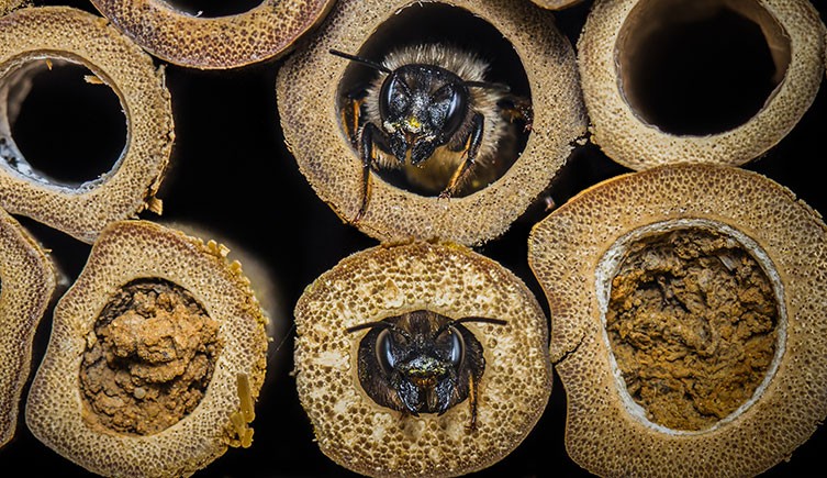
Bee hotels have become popular additions to gardens, designed to support wild bees by providing them with nesting sites. Solitary bees, unlike honey bees, live in natural and man-made cavities which can be easily provided with nesting habitats. A previously published Garden Professors blog offers valuable insights into creating artificial nesting structures for these bees, emphasizing the importance of proper design and placement. However, if you’re thinking about installing a bee hotel, I’d urge you to reconsider – some studies suggest that bee hotels, if not correctly maintained, can inadvertently harm the very pollinators they’re meant to help.
While bee hotels offer nesting opportunities, there is almost no research showing that they have a positive effect on bees. Some researchers also think bee hotels can become hotspots for parasites and pathogens (MacIvor & Packer 2015). High-density nesting sites can facilitate the spread of diseases, similar to how bird feeders can become transmission points for avian illnesses. Bees are particularly vulnerable to viruses, microsporidians, and fungal agents which can spread via exposure to feces or even through pollen left behind by bee visitors. Bee hotels can also attract bee predators – nesting aggregations of wild bees that are artificially close together might be attractive to parasitic wasps which infiltrate nests, laying their eggs inside and jeopardizing the bee larvae.
Bee hotels may still have their place, especially in community gardens where they can serve as a point of conversation and provide beauty and interest as a form of garden art. However, given the risk for disease spread, here are some tips for maintaining a bee hotel.
Best Practices for Bee Hotel Maintenance
To ensure bee hotels remain beneficial:
Annual Cleaning: After bees have emerged in the spring, clean the hotel thoroughly. Remove and replace any natural reeds or paper straws. For wooden blocks, use a thin bottle brush or compressed air to clean out debris.
Use Removable Nesting Materials: Opt for bee hotels with removable tubes or liners. This design facilitates easier cleaning and reduces the risk of disease buildup.
Proper Design: Ensure that nesting holes are closed at one end to prevent parasites from accessing the nests from behind.
Limit Nest Density: Avoid overcrowding by limiting the number of nesting tubes. A lower density reduces the chances of disease and parasite spread
Create Habitat: Leave undisturbed, unmulched areas in the borders and corners of your garden so that bees can nest naturally in the ground. Some bees also nest in dead twigs and hollow stems and branches, so consider leaving some behind for them.
Do you have a bee hotel in your garden? What has been your experience with them?
References:
MacIvor, J. S., & Packer, L. (2015). ‘Bee hotels’ as tools for native pollinator conservation: a premature verdict?. PloS one, 10(3), e0122126.