In my last blog post in late August, the Atlantic tropical season was just beginning to wake from a long nap, with several areas of interest appearing on the National Hurricane Center’s (NHC) map. Since that time, the season has become incredibly active, with Hurricanes Fiona and Ian causing tremendous damage in North America. Other parts of the world have also seen damaging storms, including Hurricane Kay in the Eastern Pacific, post-typhoon Merbok in Alaska, and Typhoons Hinnamnor in South Korea, Nanmadol in Japan, and Noru in the Philippines. So, with apologies to those who live far from hurricane parts of the world, I want to talk one more time about tropical systems.

Where do we stand with the tropical season now?
As I am writing this on Thursday morning, September 29, I hear the sound of Ian’s wind in the tulip poplar trees outside my house in Athens, GA. Ian is still in central Florida, just about to come off the coast into the Atlantic Ocean, so that gives you an idea of how far the influence of a tropical storm can spread, especially with a strong high-pressure center to our north that is increasing the pressure gradient driving the winds. Ian made landfall yesterday afternoon near Fort Myers, Florida, as an almost-category 5 storm, with winds of 150 mph (some reports say 155 mph). The videos I saw yesterday showed the power of the storm, with tremendous wind gusts and a storm surge that surpassed 10 feet in some places. I know the damage is horrific, and some of those areas will never recover completely from the storm, as buildings have been washed away and even shorelines may have changed due to the force of the wind and water. Since Ian is expected to curve back toward the East Coast on Friday and may strengthen again, its effects are not over yet. Fortunately, a weaker storm has lower impacts, but folks along the Georgia and South Carolina coasts will be feeling those impacts in the next few days before Ian moves out of the area and dissipates.

Hurricane Fiona lashed Puerto Rico and the Dominican Republic with rain of up to two feet in some places around September 18-19 before moving rapidly to the north and slamming into Nova Scotia as a post-tropical cyclone on September 24. It caused tremendous damage in both places from storm surge, wind, and rains. The floods in Puerto Rico destroyed a lot of local farms and gardens in the southern half of the islands where the rain was heaviest and in doing so, eliminated an important source of locally produced food as well as disabling a fragile power grid that had not yet recovered from Hurricane Maria in 2017. The storms in other parts of the world have had similarly bad effects on the lands over which they moved, with loss of trees and buildings and high storm surges wiping out coastal infrastructure. Not all hurricane impacts are bad, however, since the rain from Hurricane Kay in southern California helped reduce drought conditions there in a time when not much rain usually falls in that part of the world.
Predicting the tracks of hurricanes
One of the questions that have arisen with Hurricane Ian has been the prediction of where the hurricane would go. Predicting the track of a hurricane is an art that includes the use of multiple computer models that simulate conditions over the life of the storm. That includes sea surface temperature, vertical atmospheric structure, and the surrounding wind field which will push the storm around. On the news you will often see maps that show all the individual model results on one map, which ends up looking like a mass of spaghetti noodles, hence the term “spaghetti models”.

Forecasters look at all the individual model tracks together to see how consistent they are with each other and where the differences lie. Then the human forecasters use their knowledge of how well those models behave under different weather conditions to create a “forecast cone” that shows the region where the center of the storm is likely to go.
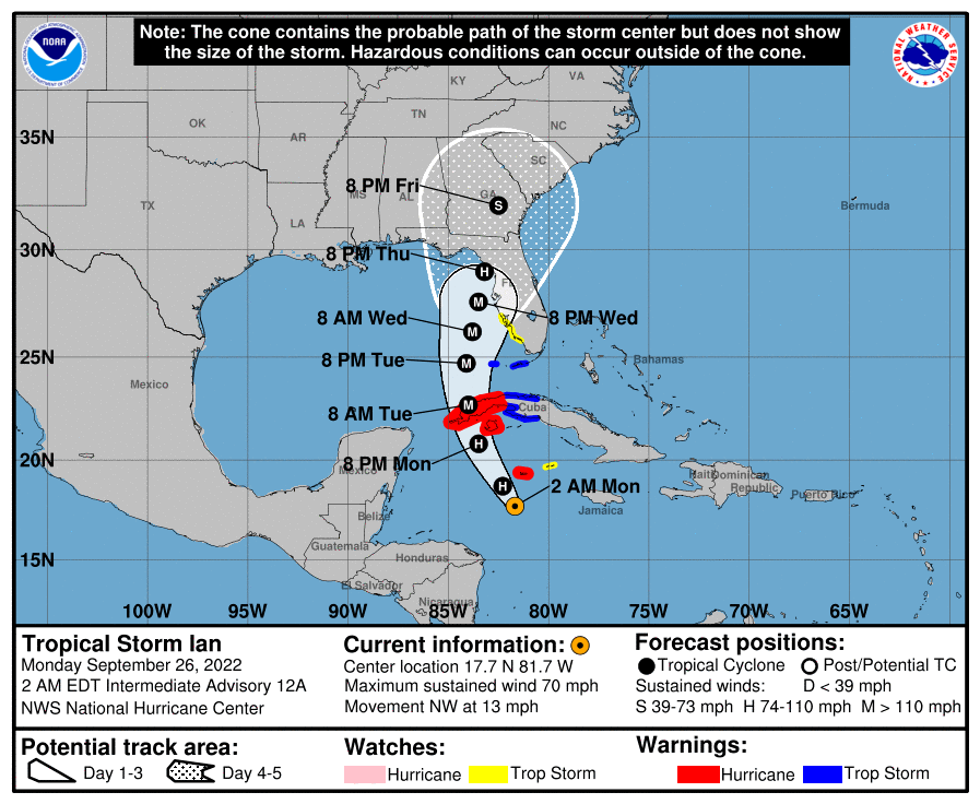
No one model is right all the time because they weigh different weather factors differently. In the case of Ian, the models run by European weather services did better, but that is not always the case. Generally, they say that 2/3rd of the time, the central low pressure will stay within the predicted cone, although the storm itself is usually much larger than the cone and hazards like high wind, heavy rain, tornadoes, and storm surge can and do occur far outside the cone. If there is a lot of spread in the models, then the forecast cone is wider, indicating that they are less certain about where the storm will go.
The models are run every six hours or so, and each time the cone is updated to include model results that include new weather data observed since the last forecast was issued. As this happens, people that are in or near the cone must respond to the forecast by deciding whether to evacuate or stay in place and where to go if they do leave, since they don’t want to evacuate to a location that could be hit by the storm if the cone shifts. When the forecast is especially tricky, as it was with Ian, the movement of the cone over time can become overwhelming to people who just want to find a place they will be safe. The forecasts of where the storm is likely to travel are improving over time, but the tracks will never be 100% accurate because the atmosphere is a complicated place that we can’t simulate perfectly using even the best computers, so confusion is likely to continue to occur in future storms.

Dealing with flooded gardens
Since this is a blog about gardening, I want to end up mentioning what impacts these storms have on gardens. Coastal areas where there is a storm surge will see inches to feet of seawater flow over their land. The water contains salt but can also contain toxic chemicals from boats and tanks that are damaged by floating debris or strong waves. The salt and chemicals can kill garden plants but also may get deposited in the soil as the water sinks in, leaving toxic residue behind. The physical motion of the water on and off the land can also scour the topsoil and change the soil structure or deposit sand on top. Saturated soils can drown the plants by keeping oxygen from reaching the roots of plants. And of course, the howling winds can snap the plants, bushes, and trees above the ground, leading to damage that can be taken advantage of by pests and diseases. In areas where there is heavy rain and freshwater flooding, salt is not usually a problem, but all the other problems with too much water can occur there, too. For those who live where storm damage is heaviest, helping their gardens to recover will be a long process even if their houses survive the storm.

The Atlantic tropical season is not over yet for us in the Southeast, but I know that in other parts of the United States and the world, the seasons march on, so in the next months I will move on to talk about fall frosts and the upcoming winter. Thanks for bearing with me as I explore tropical storm systems. Please keep all of those affected by our storms this year in your thoughts and prayers as they work to recover from damage and disaster.
Lovely sunsets after the brutal landfall and a great blog…We are in Greenville SC and had a misty rain you could see the cresent cumulus cloud shapes,backlit by brilliant light. I’will be back.
Wonderful explanation, thanks so much. We live in the path of Fiona, and certainly will be looking more closely at our trees in relation to the house, and trying to find as much room for them as possible whilst reducing risk of our home. It saddens me that people pay little attention to how close to their houses people plant trees while failing to consider their mature height. Also, the impact that things like streets and sidewalks can have on their roots, weakening them in ways that can pre-determine the directions they fall.
Having grown up in South Florida, I grieve the huge long-term mess generated by these storms, having been through 10 or so in my life. If you look at the satellite views on google maps of both the Florida Keys and around Miami off the coast (such as the Coconut Grove Bayfront), you will see all the unclaimed wreckage.
Changes in atmosphere are highly unpredictable. I thought I was (relatively) free of hurricanes