I got a Facebook message early this week from a friend in Sacramento CA that said after over 200 days with no rain, she got 4.83 inches in a 24-hour period from the latest extreme rainfall that occurred over northern California. Others have reported up to a foot of rain in three days. If you follow the news, you may have heard the term “atmospheric river” used to describe the torrential rains and flooding that have occurred this week in San Francisco and other parts of Northern California. In this post, I want to explain what atmospheric rivers are and how they affect rain climatology in the Western U.S. as well as other parts of the United States and the world.

Tahquamenon Falls–Autumn. Source: Wfgc, Commons Wikimedia.
What is an “atmospheric river”?
The term “atmospheric river” first appeared in the modern scientific literature in the early 1990s. Since it was first used, there has been a lot of discussion about what the term actually means. Commonly, it is seen as a band of very moist air flowing into a coastal area, bringing the potential for a lot of rain to the region that is at the downwind end of the flow. In some respects, it is like being on the receiving end of a firehose streaming high-intensity water right towards you! After a lot of discussion by meteorologists (described in this Bulletin of the American Meteorological Society article) the official definition in the Glossary of Meteorology became:
Atmospheric river – A long, narrow, and transient corridor of strong horizontal water vapor transport that is typically associated with a low-level jet stream ahead of the cold front of an extratropical cyclone. The water vapor in atmospheric rivers is supplied by tropical and/or extratropical moisture sources. Atmospheric rivers frequently lead to heavy precipitation where they are forced upward—for example, by mountains or by ascent in the warm conveyor belt. Horizontal water vapor transport in the mid-latitudes occurs primarily in atmospheric rivers and is focused in the lower troposphere. Atmospheric rivers are the largest “rivers” of fresh water on Earth, transporting on average more than double the flow of the Amazon River.
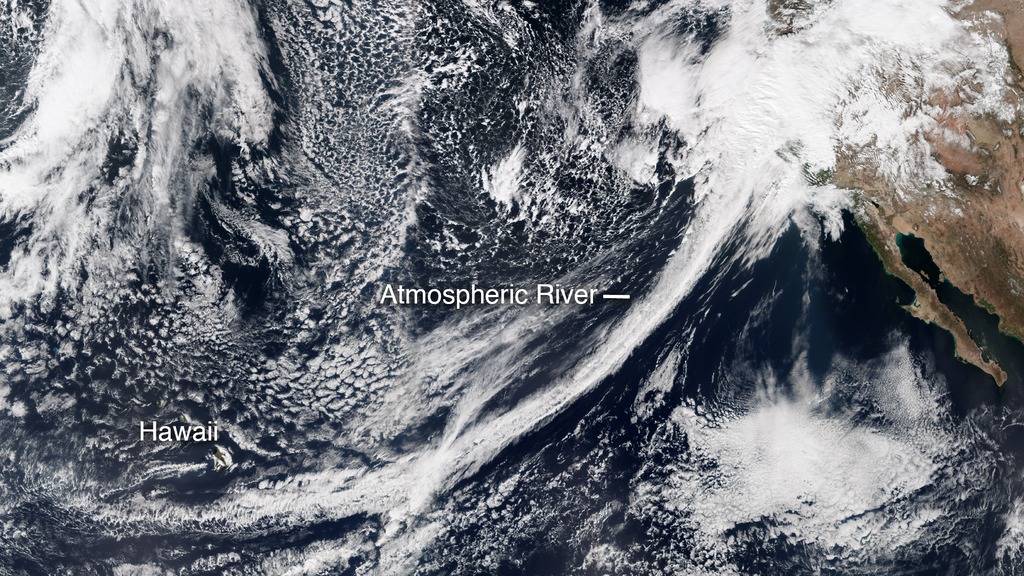
Source: NASA Earth Observatory
Why do atmospheric rivers produce so much rain?
The strong flow of moisture into a region provides an excellent source of water vapor for the development of heavy rain, especially if it is moving into an area with flow up mountain slopes that can help storms develop vertically. That enhances the rain-producing process. The West Coast of the United States provides a perfect location for the occurrence of atmospheric rivers since there is a broad expanse of ocean to provide the water vapor, dynamic storms that concentrate the flow into bands that can stretch all the way from the Hawaiian Islands to California (which explains an alternate name, “Pineapple Express”), and mountains near the coast to provide lifting for the moist air once it comes onshore. Cliff Mass of the University of Washington often discusses them in his blog on the weather of the Pacific Northwest.

Do atmospheric rivers occur in other places?
The short answer is Yes! While historically they are discussed most often when talking about weather on the West Coast, atmospheric rivers (ARs) can and do occur in other places as well. Anywhere that has a good source of moisture plus dynamic storms with strong airflow can experience ARs. In the Southeastern U.S., we get them when strong flow from the Gulf of Mexico or the Atlantic Ocean feeds into our region, usually ahead of a strong low pressure center that provides the necessary dynamics to create a narrow band of moisture feeding into the region. According to research by University of Georgia researchers, they occur most often in the cold months of November through March but can occur in any month of the year. In the Southeast, we get about 40 events per year that are classified as ARs. I was surprised to read that there are slightly more events on the East Coast than along the Gulf of Mexico, but anywhere along the Southeast coast can be affected. No trend towards more or fewer events was seen in the 1979-2014 period.
NOAA’s Physical Sciences Laboratory’s page describing ARs says that on average, about 30-50% of annual precipitation in the west coast states occurs in just a few AR events, thus contributing to water supply. ARs move with the weather and are present somewhere on the Earth at any given time. This site has some great resources for tracking and forecasting ARs around the world.
Of course, atmospheric rivers are not the only source of heavy rain events, but they are one of the primary sources for the West Coast. In other areas, tropical systems like slow-moving hurricanes or stalled fronts can also drop a lot of rain. You can also get very heavy rains from small local systems of thunderstorms if conditions are right, especially if the storms “train” or move one after another over the same area like cars on a freight train. We saw this in the Nashville area a few weeks ago, where the heavy rains resulted in significant flooding over a few counties.

Rain garden in the Allen Centennial Gardens on the campus of the University of Wisconsin-Madison. Source: James Steakley, Commons Wikimedia.
How do atmospheric rivers and other heavy rain events affect gardeners?
If you are a gardener in the Western United States, you are already well aware of the long dry season over the summer followed by bouts of rain that can occur over the winter months. The timing of the switchover from dry to wet conditions depends on how far north you are on the coast, with the summer dry spell coming earliest in southern California and moving northward with the position of the jet stream as the summer progresses. Dealing with the effects of an AR is like any other attempt to protect your garden against heavy rainfall, and can mean proactive action to make sure that water-sensitive plants and trees are not located in low-lying areas where rain collects. This 2013 article from the Garden Professors blog on-site assessment is still good advice for planning ahead for soggy conditions by walking through your property in the rain. Designing for erosion control, such as rain gardens, can also help divert water in high-intensity rainfall.
In spite of the heavy rain that fell in this last atmospheric river event, the rainfall barely made a dent in the long-term drought that is present across a lot of the Western U.S. Drought will continue to be a part of the hydrologic cycle that affects gardeners, farmers, and water managers across that region and across the world.
5 thoughts on ““Cry Me A River””