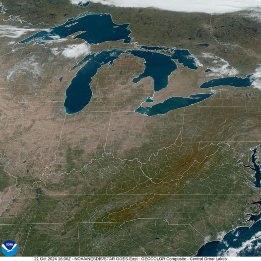
If you find yourself singing “How Dry I Am” these days, you might be under the influence of a large, stationary area of high atmospheric pressure. This past month, most of the eastern United States has been trapped in this pattern, with warm temperatures, clear skies, and no rain at all for most of the past month. In fact, many cities are on the verge of setting new records for low or no precipitation for the month of October, and some may even break records for the driest month ever. In this post, I will discuss what high pressure is, how it affects precipitation and health, and what impacts these may have on your gardens.

What is atmospheric pressure?
Pressure is a measure of the force of the atmosphere pushing down on the surface of the earth. This is caused by the weight of the air above that surface. As you go up in the atmosphere in an airplane or as you climb a mountain, the amount of air that is above you decreases and the pressure goes down. Pressure also changes horizontally as differences in the temperature around you cause variations in the density of the air, leading to areas of high pressure where the air is more dense and low pressure where it is less dense. Wind is just the movement of air in response to differences in pressure as the atmosphere tries to equalize pressure everywhere horizontally. In the vertical, the pressure gradient pulling air up is balanced by gravity pulling the air down. The wind at the surface is controlled not only by the variations in pressure at the surface but also by friction and the revolution of the earth around its axis, which diverts moving air to the right of the original movement in the Northern Hemisphere and to the left in the Southern Hemisphere (we call that the Coriolis force). Because of the combination of these forces, air tends to spiral into the center of the lowest pressure and spiral out of the center of the highest pressure.
How does atmospheric pressure relate to precipitation?
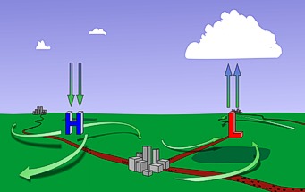
As the air moves into the center of low pressure, it meets in the middle and rises up, since it cannot go down into the earth. Rising air cools off as the pressure decreases and eventually the water vapor in the air condenses and forms clouds and sometimes precipitation. In the middle of high pressure areas, the air sinks, leading to air that is heating up and evaporating any clouds that might have formed elsewhere. Skies may be bright blue due to the lack of water vapor in the descending air. A complete circulation is formed when air at the surface of the high moves out away from the center towards areas of low pressure, then rises up and spreads out away from the surface low, moving into the top of the high pressure column and sinking towards the surface. You can see this schematically in the diagram below.

When an area of high pressure persists over an area for a long time, the sinking air leads to persistent sunny skies and low humidity, making it very difficult for clouds and rain to form. In summer, these long-lasting high pressure centers can lead to heat domes and oppressive and dangerous conditions such as occurred in the Pacific Northwest a few years ago. In the winter, high pressure is often associated with cold outbreaks of frigid, dry and dense air moving south from the Arctic (in the Northern Hemisphere). Those conditions lead to freezes caused by temperatures that fall to 32 F (0 C) or lower due to low winds and no clouds to trap the heat near the surface.

This fall has been a textbook case of a strong high pressure that has parked over the eastern half of the United States, causing day after day of warm and sunny weather and almost no rain at all. I often think that a drought is just too many days in a row of nice weather (assuming you prefer sunshine, which not everyone does). Fall is the time of year when we tend to have the longest periods of dry weather in the Southeast, but the dry spell does not usually last as long as it has done this year. If you enjoy warm and quiet weather (or sometimes cooler and less humid weather if some dry air has moved in from the north), fall is the time for you to really enjoy your garden before it shuts down for the winter. The dry conditions are good for many farmers too, because the harvest of commodity crops like cotton are easier when the plants dry up. Grape growers also appreciate the dry conditions because it concentrates the sugar in the grapes, leading to more tasty wines. Large-scale areas of high pressure around 30 degrees North and South latitudes are related to the formation of deserts like the Sahara and the Desert Southwest in the United States because the sinking air prevents the occurrence of precipitation, although it can rain there too when the monsoon blows moist air into the region and heat makes it rise to form clouds and rain.

How does high pressure relate to health?
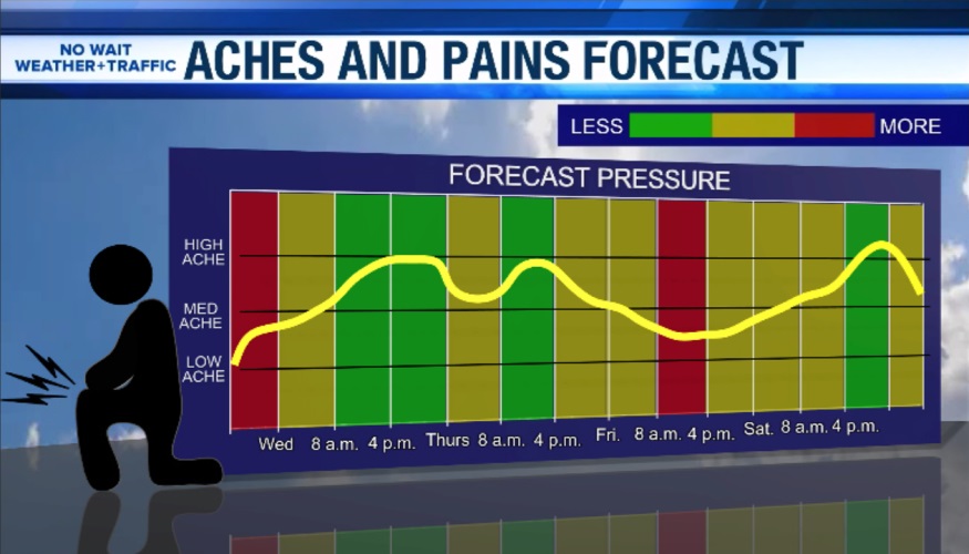
Air pressure variations can lead to health issues in some people. Most people seem to be affected by low pressure, which can cause sinuses and ears to hurt and bother some people’s joints. Changes from high to low pressure associated with the movement of cold fronts also bother many people with arthritis and can cause headaches in some sensitive people. In high pressure areas, most people feel more alive and active. It is hard to know how much of that is due to the pressure and how much is due to the persistent sunshine and lack of rain, though. Interestingly, there is some evidence that more women give birth when the air pressure is low, especially when there is a big change due to an incoming tropical cyclone.

Sinuses, inversions and trapping of aerosols
Air quality also suffers under high pressure because the sinking air traps pollutants near the surface of the earth. This can include soot, smog, and even pollen. The temperature of the air above the surface often rises with height before cooling off as you go higher in the atmosphere. We call this an inversion because we normally expect temperature to decrease as you rise away from the earth, and instead it rises over a layer near the ground before cooling off above that layer. Farmers spraying some herbicides are not allowed to spray when there is an inversion because it can lead to concentration of the chemical near the ground and drift into neighbors’ fields, causing damage to the plants there. This can also happen in home gardens if you have a neighbor that uses a lot of chemical sprays in his or her yard. In the worst cases, a strong and persistent inversion can lead to dangerous levels of pollutants that can cause harm to people with lung conditions like asthma. Smoke from wildfires can also get trapped under the inversion, adding to the pollutant load.

How you can plan for high pressure impacts
If you know that high pressure is forecast for your area, you can use that information to plan for the kind of weather you are likely to experience while it is in place. If it persists over the area, it will be dry and you may have to increase your watering. Plants may get dustier and could be affected by trapped pollution and chemical treatments, leading to spotting or discoloration of the plants and eventually death as the pollutants affect the soil. If you need to work outdoors during persistent high pressure, make sure you monitor the air quality levels so you do not irritate your lungs or dry them out in the low humidity of the sinking air.
Enjoy the days of high pressure as you work in your gardens in the sunny conditions. Low pressure will soon come and bring rain and clouds. We need both to keep our gardens and our gardeners happy!

2 thoughts on “Feeling high and dry?”