Feeling high and dry?

If you find yourself singing “How Dry I Am” these days, you might be under the influence of a large, stationary area of high atmospheric pressure. This past month, most of the eastern United States has been trapped in this pattern, with warm temperatures, clear skies, and no rain at all for most of the past month. In fact, many cities are on the verge of setting new records for low or no precipitation for the month of October, and some may even break records for the driest month ever. In this post, I will discuss what high pressure is, how it affects precipitation and health, and what impacts these may have on your gardens.

Autumn leaves of a northern red oak, Toulouse, PierreSelim, Commons Wikimedia.

What is atmospheric pressure?

Pressure is a measure of the force of the atmosphere pushing down on the surface of the earth. This is caused by the weight of the air above that surface. As you go up in the atmosphere in an airplane or as you climb a mountain, the amount of air that is above you decreases and the pressure goes down. Pressure also changes horizontally as differences in the temperature around you cause variations in the density of the air, leading to areas of high pressure where the air is more dense and low pressure where it is less dense. Wind is just the movement of air in response to differences in pressure as the atmosphere tries to equalize pressure everywhere horizontally. In the vertical, the pressure gradient pulling air up is balanced by gravity pulling the air down. The wind at the surface is controlled not only by the variations in pressure at the surface but also by friction and the revolution of the earth around its axis, which diverts moving air to the right of the original movement in the Northern Hemisphere and to the left in the Southern Hemisphere (we call that the Coriolis force). Because of the combination of these forces, air tends to spiral into the center of the lowest pressure and spiral out of the center of the highest pressure.

How does atmospheric pressure relate to precipitation?

As the air moves into the center of low pressure, it meets in the middle and rises up, since it cannot go down into the earth. Rising air cools off as the pressure decreases and eventually the water vapor in the air condenses and forms clouds and sometimes precipitation. In the middle of high pressure areas, the air sinks, leading to air that is heating up and evaporating any clouds that might have formed elsewhere. Skies may be bright blue due to the lack of water vapor in the descending air. A complete circulation is formed when air at the surface of the high moves out away from the center towards areas of low pressure, then rises up and spreads out away from the surface low, moving into the top of the high pressure column and sinking towards the surface. You can see this schematically in the diagram below.

High pressure and drought on short and long time scales. Source: Space Science and Engineering Center, University of Wisconsin-Madison.

When an area of high pressure persists over an area for a long time, the sinking air leads to persistent sunny skies and low humidity, making it very difficult for clouds and rain to form. In summer, these long-lasting high pressure centers can lead to heat domes and oppressive and dangerous conditions such as occurred in the Pacific Northwest a few years ago. In the winter, high pressure is often associated with cold outbreaks of frigid, dry and dense air moving south from the Arctic (in the Northern Hemisphere). Those conditions lead to freezes caused by temperatures that fall to 32 F (0 C) or lower due to low winds and no clouds to trap the heat near the surface.

Clear conditions over the Eastern US on 21 October, 2024. (Note the autumn leaves in some locations.) Source: NOAA.

This fall has been a textbook case of a strong high pressure that has parked over the eastern half of the United States, causing day after day of warm and sunny weather and almost no rain at all. I often think that a drought is just too many days in a row of nice weather (assuming you prefer sunshine, which not everyone does). Fall is the time of year when we tend to have the longest periods of dry weather in the Southeast, but the dry spell does not usually last as long as it has done this year. If you enjoy warm and quiet weather (or sometimes cooler and less humid weather if some dry air has moved in from the north), fall is the time for you to really enjoy your garden before it shuts down for the winter. The dry conditions are good for many farmers too, because the harvest of commodity crops like cotton are easier when the plants dry up. Grape growers also appreciate the dry conditions because it concentrates the sugar in the grapes, leading to more tasty wines. Large-scale areas of high pressure around 30 degrees North and South latitudes are related to the formation of deserts like the Sahara and the Desert Southwest in the United States because the sinking air prevents the occurrence of precipitation, although it can rain there too when the monsoon blows moist air into the region and heat makes it rise to form clouds and rain.

Desert Botanical Gardens in Phoenix, Arizona, Kevin Dooley from Chandler, AZ, USA, Commons Wikimedia.

How does high pressure relate to health?

Air pressure variations can lead to health issues in some people. Most people seem to be affected by low pressure, which can cause sinuses and ears to hurt and bother some people’s joints. Changes from high to low pressure associated with the movement of cold fronts also bother many people with arthritis and can cause headaches in some sensitive people. In high pressure areas, most people feel more alive and active. It is hard to know how much of that is due to the pressure and how much is due to the persistent sunshine and lack of rain, though. Interestingly, there is some evidence that more women give birth when the air pressure is low, especially when there is a big change due to an incoming tropical cyclone.

A chart shows the expected impact of Houston’s atmospheric pressure on “aches and pains” this week. (KIAH)

Sinuses, inversions and trapping of aerosols

Air quality also suffers under high pressure because the sinking air traps pollutants near the surface of the earth. This can include soot, smog, and even pollen. The temperature of the air above the surface often rises with height before cooling off as you go higher in the atmosphere. We call this an inversion because we normally expect temperature to decrease as you rise away from the earth, and instead it rises over a layer near the ground before cooling off above that layer. Farmers spraying some herbicides are not allowed to spray when there is an inversion because it can lead to concentration of the chemical near the ground and drift into neighbors’ fields, causing damage to the plants there. This can also happen in home gardens if you have a neighbor that uses a lot of chemical sprays in his or her yard. In the worst cases, a strong and persistent inversion can lead to dangerous levels of pollutants that can cause harm to people with lung conditions like asthma. Smoke from wildfires can also get trapped under the inversion, adding to the pollutant load.

A meteorological inversion in the southernmost tip of the Netherlands, Rhetos, Commons Wikimedia.    

How you can plan for high pressure impacts

If you know that high pressure is forecast for your area, you can use that information to plan for the kind of weather you are likely to experience while it is in place. If it persists over the area, it will be dry and you may have to increase your watering. Plants may get dustier and could be affected by trapped pollution and chemical treatments, leading to spotting or discoloration of the plants and eventually death as the pollutants affect the soil. If you need to work outdoors during persistent high pressure, make sure you monitor the air quality levels so you do not irritate your lungs or dry them out in the low humidity of the sinking air.

Enjoy the days of high pressure as you work in your gardens in the sunny conditions. Low pressure will soon come and bring rain and clouds. We need both to keep our gardens and our gardeners happy!

Autumn Sky-Panoramio. Source: FoxyStranger Kawasaki, Commons Wikimedia.

Seeing red – in autumn leaves and in misdiagnoses
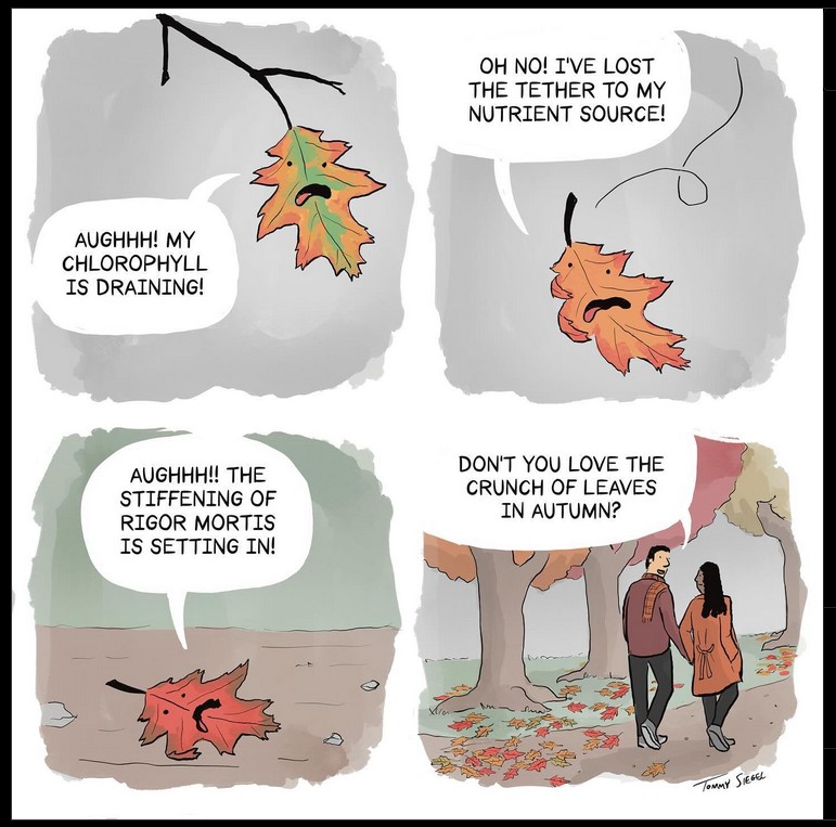
Existential dread – the botanical version. (Thanks to Tommy Siegel’s creative talents)

While the onset of autumnal leaf color change reminds us that winter is coming, there are many other reasons why leaves turn red. Knowing why and how leaves turn red is key in accurate diagnosis.

Once near-freezing temperatures occur, leaves seem to turn red overnight.

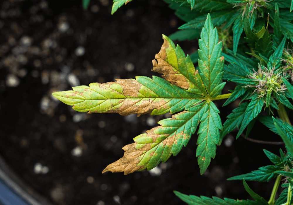
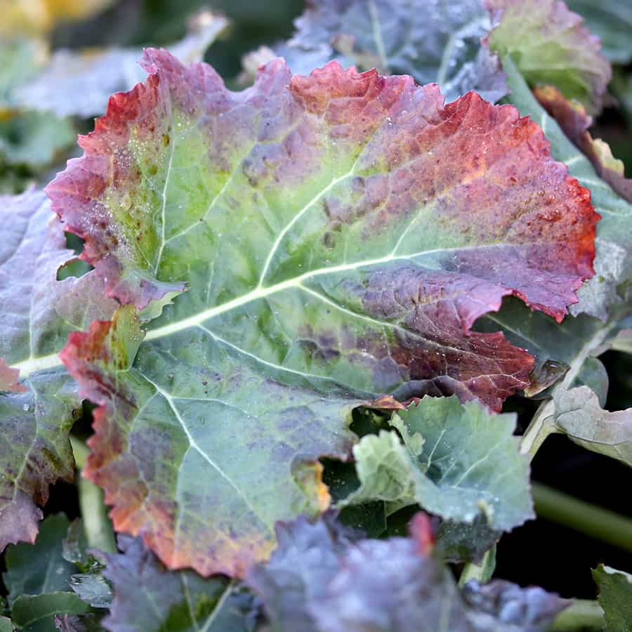
These are examples of leaf reddening misdiagnosed as phosphorus deficiency:

These leaves are not phosphorus deficient, either.

Leaf reddening here is due to solar damage (leaf scorch)

Congratulations to accurate diagnosticians at UCANR! This is indeed phophate deficiency. Damage is not localized as in the previous images.

Lack of sufficient phosphate causes overall leaf reddening among other symptoms.

Here are some other underlying causes behind leaf reddening.

This Cornus kousa (dogwood) is sitting in a perched water table. Poor soil drainage is causing anthocyanins to accumulate at the margins of the leaves.
Leaf reddening on a Cornus spp. (dogwood) suffering from anthracnose

If you’re interested in learning more about how and why leaves turn read, be sure to download my most recent factsheet, appropriately titled “Why do leaves turn red?” ] It’s peer-reviewed and relevant to any part of the world.

Enjoy this Halloween treat!

Getting ready for an extreme weather event

For those of us in the Southeastern United States, this past week has been a whirlwind of preparation for Hurricane Helene, followed by the terrifying storm itself and now, for some people, months of clean-up and houses, yards, and gardens that may never be the same. My post this week (I did not get to it last week because of the impending storm) will be about how to prepare for an extreme weather event, including where to find accurate and timely information on weather forecasts and how to prepare your house and garden for the extreme weather you may suffer. While we just went through a hurricane, this could apply equally to an ice storm or blizzard, derecho, tornado, or any rapidly occurring weather event. No matter where you live, you will experience extreme weather at some point and need to be ready for it. My post from last month, https://gardenprofessors.com/how-would-your-garden-handle-a-12-inch-rainfall/, was surprisingly prescient, since Helene also brought extreme rainfall to the Southeast, particularly to western North Carolina and Virginia and to the area around Atlanta, GA. Our hearts go out to all of the people affected by Helene and other serious weather disasters.

Hurricane Helene and Tropical Storm John together on September 25, 2024. Source: NASA.

Preparing your property and garden for damaging wind and rain conditions

The best way to deal with an extreme weather event is to prepare for it well ahead of time. I used to play a game with my son when he was young: “Name all the ways that something could go wrong (in his case, what could make a train or airplane crash).” It is a surprisingly effective way to make you think about possible dangers that might lurk around your home if a severe weather event occurs and what you might have to do to minimize them. If you can identify the risks of an event, then you can address them before the roof starts to blow off and the trees start falling.

Storm damage from Ophelia, Dublin, Ireland, October 2017. Source: William Murphy, Commons Wikimedia.

The first step is to look around the outside of your house for any potential threats to your property that could become safety issues in strong winds or heavy rains. If you have trees, are they healthy? Are there any low-lying or diseased branches that could come loose in a strong wind and hit your house or car? Could a 50-mph wind from the southwest (or whatever direction your storms usually come from) blow them into your windows or onto your roof? Are there any areas on the outside of your house that are in poor repair and in danger of failing in a storm such as a loose railing or fence? If you like decorative items in your garden like garden gnomes or shiny balls, can you remove them before a storm approaches so that they don’t become wind-borne missiles? You should also consider potential areas where erosion might be enhanced by the ground cover or slope and determine if there are ways to slow the flow of water to preserve your soil and garden design.

Once you identify potential problems in your yard, you can repair them before a storm comes. But you should also make sure that you have adequate insurance coverage and that you document what you have before a storm hits with an inventory or video recording. You might also need special insurance to cover extreme events; I read today that less than 1% of all residents of western North Carolina had flood insurance, even though many of them live in flood-prone areas. Floods are not covered by most homeowners insurance policies. Of course, there could be many reasons for not buying it, including high costs, but if an extreme event occurs, you are going to wish you had it.

Cabbage field eroded by Helene rainfall.

Identifying location concerns that could affect your safety

No matter where you live, there are bound to be risks due to the location of your property. If you live on top of a hill, you are prone to experience more lightning and higher winds and potentially more snow since the temperatures at higher elevations are generally lower. If you live in a river valley, your property and gardens would be more vulnerable to floods but also to freezes since cold air drains downslope to low-lying areas. When you decide where to live, consider the land the house and garden are on and also how you get there, whether you have to cross rivers or go through areas that are heavily wooded, which could be a problem in high winds but also potentially in a wildfire. Where you get your water could also be a concern if your well has an electric pump and power is likely to go out.

Rainy day horses. Source: Sini Merikallio, Commons Wikimedia.

Get ready to go or stay

Preparing for an extreme event means planning for providing food, shelter, and water for your family and pets if you plan to stay and planning for an evacuation if it is not safe to stay. There is a lot of information out there about this planning process and I am not going to list everything here but you will find some links at the end of this blog that you may find helpful. As I write this almost a week after Helene came through the Southeast, there are many people here whose power is still out and who may not be able to travel because of all the trees and power lines that are down in their neighborhood and who have no access to clean water because the water plants were destroyed or the electric pumps on their wells no longer work. It usually takes about 72 hours for outside help to start getting supplies into affected areas, so you need to plan for several days and perhaps much longer to provide everything you need. Eventually, help will come from a variety of federal, state, and local agencies and non-profits but often the first help comes from a neighbor with a chain saw or extra water. If you evacuate, you will need a plan to get out safely, including more than one possible evacuation route, plenty of gas for your car, copies of important documents, and a place to go, which may include housing for pets or livestock.

Getting the weather information you need to make good decisions

Once you have your plan for severe weather, you need to monitor the situation for potentially threatening situations. A smartphone weather app is an easy way to get your daily weather for regular planning purposes but is not adequate for situations when weather might be changing rapidly since the apps are often updated only once or twice a day. In severe weather, an old forecast is a bad forecast because things may be quickly changing and you need the latest information.

Hourly forecast graph from the National Weather Service.

There are a number of apps and websites that you can use to monitor extreme weather events, including the National Weather Service local forecasts for frequently updated information, watches for potential severe weather, and warnings for when it is spotted. The National Hurricane Center is the official source of hurricane and tropical storm warnings and their maps are updated every three hours when a storm is present. Beware apocalyptic posts on social media that often show a single worst-case model run that has practically no chance of occurrence just to gain attention and clicks. Stick to expert guidance from trusted sources. You can also get information on what local conditions you might experience and the timing of wind and rain using the hourly weather forecast from the National Weather Service, although in a rapidly changing extreme weather event even these may not change quick enough to capture the evolution of the storm. Weather radios and some smartphone apps that are designed can provide information about watches and warnings based on your location. If you live in an area that is prone to flooding or severe weather or is in a floodplain or near the coast of the ocean, then you should pay careful attention to rain in the area upstream of you are or the likely storm surge from a tropical cyclone. Be prepared to evacuate if emergency managers ask you to.

Planning ahead can save lives

Extreme weather is something that we all need to plan for but that planning often falls by the wayside because of other pressing tasks. But if you can take the time to do some simple advance planning and be prepared to act when the event starts, you can save yourself a lot of work later on when the clean-up begins and may save your houses and gardens. You may even save your family from serious consequences! I hope that it never becomes an issue for you, but I also know that many communities, businesses, farms, and families are dealing with the consequences of extreme weather now. Thanks to help from many people, they are starting to rebuild their lives, but it will be a long time before things get back to normal and for some, it may never be the same.

Fallen Tree by Alexandre Calame, 1839-1845, oil on paper on canvas – National Gallery of Art, Washington. Source: Commons Wikimedia.

Some useful links:

Georgia Department of Public Health: Severe Weather Preparedness

Resident’s Handbook to Prepare for Natural Hazards in Georgia (good for other locations too)

Bankrate: How to Create a Home Inventory

FEMA: Hurricane Preparedness and Evacuation Planning